

This is the long version of everything Houstonopolis Creative has learned about drone real estate marketing, replacing four shorter posts that covered the same ground.
KEY TAKEAWAY
Drone coverage works best when it's flown under an active FAA Part 107 certification with Remote ID compliance, planned around what the property actually needs, and edited for accuracy rather than spectacle. It shows buyers scale and context ground photography can't, especially on properties with acreage, water frontage, or a standout lot, and it compounds with 3D/AR walkthrough content rather than competing with it.
Why Drone Coverage Still Matters
Aerial footage stopped being a novelty add-on a while ago. NAR now reports drone imagery on 83% of U.S. real estate listings, which means the real question for most sellers isn't whether to fly at all, it's whether this specific property earns the flight. Ruby Home's industry data puts homes marketed with drone photography at 68% faster to sell than the market average, and buyers shown aerial visuals are reported to be 65% more likely to schedule an in-person showing. Those numbers hold up because drone footage answers a question ground-level photos can't: what does this property, and everything around it, actually look like.
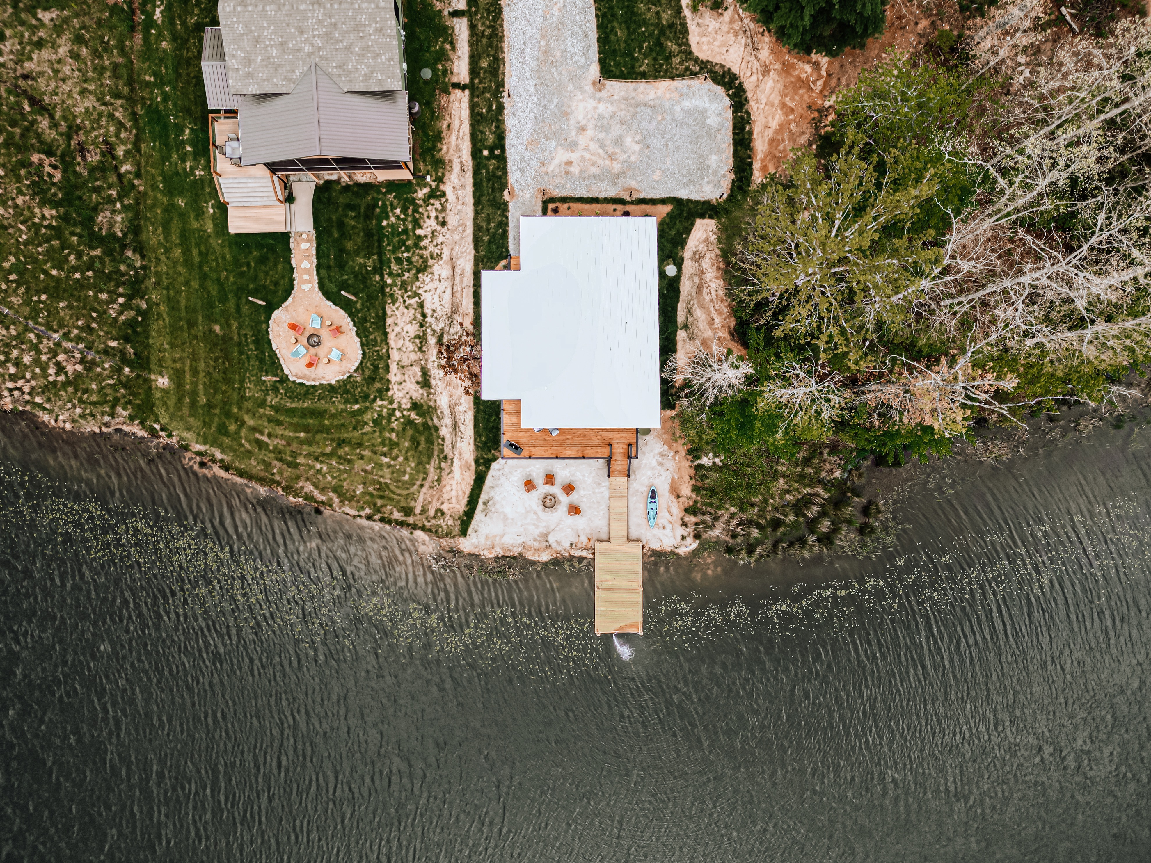
For a listing with real acreage, water frontage, or a standout lot, that context isn't decoration, it's often the reason a buyer schedules a showing at all. A buyer scrolling listings on a phone can't tell how a five-acre parcel sits relative to a creek, or how close a neighboring property actually is, from a handful of ground shots. A single well-planned aerial pass answers that in seconds.
For a small urban condo or a tightly bounded suburban lot with no distinguishing exterior features, it usually isn't worth the flight. Knowing the difference is most of what separates drone coverage that earns its keep from drone coverage that's just there because it seemed like a good idea.
Where Drone Coverage Pulls Its Weight
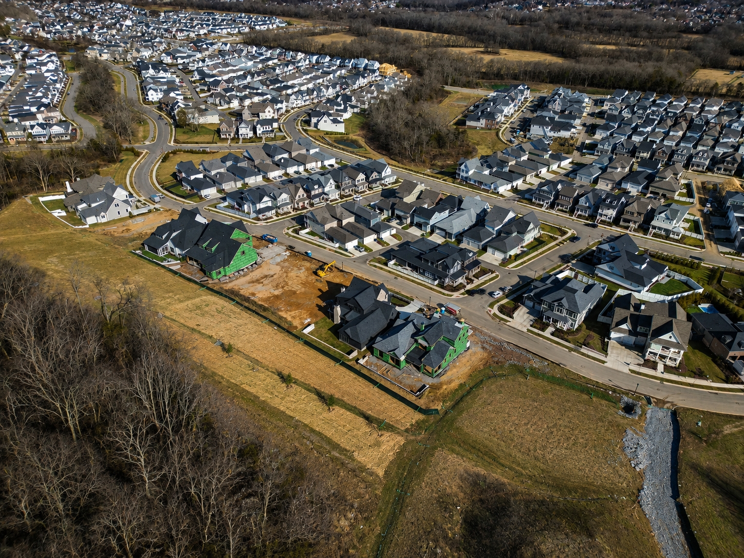
The properties where aerial footage consistently earns its cost share a few traits: meaningful acreage, water frontage, a standout or unusual lot shape, proximity to notable landmarks or amenities, or a location where the surrounding context genuinely helps sell the property. Farms, lake and river frontage, hilltop lots with a view, and larger new-construction developments all fall into this category. A downtown high-rise condo with a shared building exterior almost never does.
The Cost of Skipping It on the Wrong Listing
The flip side matters just as much. Flying a drone on a property that doesn't call for it, a tight urban lot, a shared building exterior, a property surrounded by nothing distinctive, doesn't just waste the shoot fee. It adds a cost to the listing package without adding anything a buyer will actually use, and it's the kind of decision that erodes trust with a client who's paying for marketing that should have been scoped to the property, not applied as a blanket upsell.

LOCAL INSIGHT
Middle Tennessee's mix of dense urban cores, rolling farmland, and lakefront acreage means the right drone shot list looks completely different in the Gulch than it does in Williamson County, plan accordingly.
FAA Part 107: What Compliant Drone Coverage Actually Requires
Anyone flying a drone commercially, including real estate listings, needs an active FAA Part 107 remote pilot certification. That's not paperwork for its own sake. Certified pilots have passed a test on airspace classification, weather minimums, and operating rules, and the certification has to be renewed every 24 months, which means the knowledge stays current rather than going stale after a single test taken years ago. The core of Part 107, visual-line-of-sight flight under 400 feet, which covers essentially all real estate work, hasn't changed. The FAA's newer beyond-visual-line-of-sight framework targets a different category of operations entirely and doesn't touch a standard listing shoot.
Remote ID and Registration Are Not Optional
Remote ID enforcement is active nationwide, and it applies the moment a flight is commercial, regardless of the aircraft's weight. A sub-250-gram drone flown for a paid shoot still has to broadcast Remote ID in real time; the exemption that covers casual hobbyist flying doesn't carry over to work done for a client. The FAA has moved into active enforcement on this, with penalties running from a warning for a first-time lapse up to real fines for repeat or willful violations. Registration and Remote ID aren't a box to check once, they're a standing condition of every commercial flight.
Airspace and Local Restrictions
In Middle Tennessee, that matters in a very specific way: BNA's airspace touches a meaningful chunk of the region, and flying near it without checking current airspace authorization and any active temporary flight restrictions is how a shoot turns into a legal problem instead of a marketing asset. Controlled airspace isn't limited to the immediate airport perimeter either, it extends in rings that can cover neighborhoods a listing agent wouldn't necessarily expect. Checking current airspace status before a shoot gets scheduled, not the morning of, is standard practice for any operator doing this professionally.
Weather, Safety, and Insurance
Weather minimums exist for a reason beyond comfort. Wind speed, visibility, and cloud ceiling all affect both flight safety and what the footage will actually look like, hazy or unstable conditions produce footage that reads as unprofessional even when the shot itself was technically legal to fly. Liability coverage is the other piece that's easy to overlook until it matters: a drone operator flying commercially without insurance is a real exposure for the agent or seller who hired them, not just the pilot. Proof of commercial liability coverage has become close to a standard ask from serious clients before a contract is even signed, and rates vary by operation type, equipment value, and pilot record, an operator who can't produce it on request is worth a second look before booking.
A rushed or uncertified flight is usually an obvious one in the final footage too, unsteady framing, missed golden hour, footage that clearly wasn't planned around the property's actual features. Hiring a certified, insured operator isn't just about avoiding fines, it's the baseline for footage that actually looks intentional.
Drone footage should show a buyer the truth about a property, not just its highlight reel.
Planning the Shoot: Shot Lists, Timing, and What the Property Actually Needs
A drone shoot that starts with a generic shot list, built before anyone has actually visited the property, is usually a mistake. The better sequence starts with a walkthrough, because lighting, tree cover, and the property's real standout features change what's worth flying and when.
Reading the Property Before Flying It
Middle Tennessee's rolling terrain and heavy tree cover mean a lot that looks unremarkable at noon can look completely different an hour before sunset. For properties with acreage, water frontage, or a standout lot, that golden hour window is often where the property's real story gets told, and it's worth scheduling the shoot around that window rather than whatever slot happens to be open on the calendar.
Weather Contingency Isn't Optional
Weather is the other variable that has to be planned around, not worked around. Wind and cloud cover change both safety margins and what the footage will actually look like, which is why a shoot date needs a real contingency window built in from the start, not a single locked-in time with no backup plan. Rescheduling a drone shoot because of weather isn't a sign something went wrong, forcing a flight in marginal conditions is.
Safety and Privacy Considerations
Shot planning also has to account for what's around the property, not just the property itself. Neighboring homes, people, roads, and livestock all factor into where and how a drone can safely and legally operate, and a shoot plan that doesn't account for that ahead of time risks either an unsafe flight or footage that raises privacy concerns for people who never agreed to be filmed.
Seasonal Considerations in Middle Tennessee
Tree cover changes what's visible from the air across the year in a way that matters for shoot planning. Full summer canopy can hide water frontage or lot lines that are obvious once leaves drop in late fall and winter, which means the best season to fly a heavily wooded property isn't necessarily the season it's listed. Late summer and early fall also bring a higher chance of hazy, humid conditions that flatten aerial footage and mute color, another reason a shoot date needs real flexibility rather than a single fixed slot picked to match a listing launch date.
Equipment Consistency Matters More Than Gear Specs
The specific drone model matters less than most sellers assume. What matters is a consistent, well-maintained aircraft, calibrated sensors, and an operator who knows its handling characteristics well enough to get stable footage in Middle Tennessee's variable wind conditions. A shoot plan built around unfamiliar or poorly maintained equipment is a shoot plan with a much higher chance of a wasted flight window. That said, sub-250-gram aircraft like the DJI Mini 4 Pro have become a common choice across the industry for a practical reason: the same Part 107 and Remote ID obligations apply as with any commercial flight, but the lighter footprint simplifies logistics on a residential shoot with neighbors, driveways, and overhead lines nearby.
Quick Stats
FAA Part 107 + Remote ID
Commercial operators need an active Part 107 certificate, renewed every 24 months, plus Remote ID broadcast on every flight regardless of aircraft weight.
Faster Sales, More Showings
Homes marketed with drone photography sell up to 68% faster than the market average, and buyers shown aerial visuals are 65% more likely to book a showing (Ruby Home).
Buyer Adoption
Acreage, water frontage, and standout lots, where ground-level photography can't show scale or context.
Best For
83% of U.S. real estate listings now include drone imagery, making aerial coverage a baseline expectation, not a premium add-on (NAR).
What Aerial Footage Shows That Ground Photography Can't
The single biggest advantage of drone footage is scale and context in one shot. Lot lines, proximity to water, how a property sits relative to its neighbors, the topography of a piece of land, none of that reads clearly from the ground no matter how wide the lens gets.
3D Mapping and Virtual Tour Integration
Aerial footage can also feed into 3D mapping and virtual tour products that are increasingly expected on higher-end listings, giving buyers a way to understand a property's layout and surroundings before they ever schedule a showing. For relocation buyers, out-of-state investors, or anyone who can't easily visit in person before making a decision, that context often does more work than another set of interior photos would. The data backs that up: listings that pair aerial coverage with 3D or AR walkthrough content, the kind Matterport and similar platforms produce, sell around 31% faster and often close 4 to 9% higher than listings without it. The two formats aren't competing for the same budget line, they're answering different parts of the same question a remote buyer is asking.
Where the ROI Actually Isn't There
That said, this is exactly where it's easy to overspend on the wrong properties. A small lot in a dense neighborhood with no distinguishing exterior features usually doesn't need an aerial pass, the return on that flight just isn't there, and a buyer isn't going to make a different decision because they saw the roofline from 200 feet up. The properties where aerial coverage pays off are the ones where the land itself, not just the structure sitting on it, is part of the story being told.
Showcasing Neighborhood and Surrounding Context
Aerial footage is also useful for showing a property's relationship to its surroundings: proximity to parks, water access, how close a busy road actually is, or how a new development sits relative to existing neighborhoods. That context is factual and measurable, distance to an amenity, acreage, water frontage, and describing it that way keeps the marketing grounded in what is actually there rather than in who the property might suit.
BEST FOR
Sellers, listing agents, and builders deciding whether a listing needs aerial coverage, and how to plan, shoot, and edit it once they do.
Editing Drone Footage: Accuracy Over Spectacle
Editing drone footage well means color correction, stabilization, and a cohesive edit that matches the rest of a listing's media, not filters or effects that make a property look like something it isn't.
The Trust Problem With Over-Edited Footage
Drone footage should show a buyer the truth about a property, not just its highlight reel. That's not a stylistic preference, it's what keeps a listing's media credible when a buyer walks the property in person. Overprocessed aerial footage that oversaturates a lot, hides a property's actual condition, or exaggerates its scale tends to backfire. Buyers notice the gap between the video and the walkthrough, and that gap costs trust at exactly the moment an agent needs it most, right before an offer.
Stabilization and Color Consistency
Technically, this comes down to a few specific things: smooth, stabilized movement rather than shaky or overly aggressive camera moves, color grading that matches the ground photography and video from the same shoot so the whole package feels cohesive, and selects that are chosen for what they show, not just how dramatic the angle looks.
Where AI Editing and FPV Fit In
AI-assisted editing tools can now turn a raw aerial card into a polished, color-matched cut in hours instead of days, which helps on tight listing timelines. The same rule still applies, though: use it to speed up an honest edit, not to manufacture drama that isn't there. FPV, first-person-view flythroughs that move in a single continuous shot from the exterior through a doorway and into interior space, have become a real option for the right property. That's generally new construction or a standout luxury listing where the space can actually support that kind of continuous motion, not a format to bolt onto a listing that doesn't call for it.
Delivery and Turnaround
The goal in post-production is the same as the goal on the day of the shoot: represent the property accurately, and let the property's actual features do the selling. Editing timelines should also match the pace of the rest of a listing's media, aerial footage delivered days after the photography and video isn't useful to an agent trying to launch a listing on a single timeline.
TIP
If a property borders restricted airspace, like anything near BNA's flight paths, confirm authorization before the shoot gets scheduled, not the morning of.
Where Drone Fits in a Full Marketing Package
Drone footage isn't a replacement for photography or video, it's a third format that answers a question the other two can't. Photography gets a buyer to open the listing. Video keeps them on the page long enough to picture living there. Drone footage shows them what the ground shots and walkthrough video can't, the scale and context of the property and everything around it.
Skipping it on a property where it matters isn't a budget shortcut, it's a gap in the story a buyer is trying to piece together before they ever pick up the phone. The decision isn't drone footage or not, it's whether this specific property has a story that aerial coverage is the right way to tell. Acreage, water frontage, a standout lot, or meaningful surrounding context are the signals worth looking for. A small, tightly bounded lot with nothing distinctive about its setting usually isn't.
Setting Expectations With Clients
Part of doing this well is being honest with sellers and agents up front about whether a property needs aerial coverage at all. That conversation, before the shoot gets booked, is where a lot of wasted spend gets avoided. A straightforward answer, this property's story is inside the house, not in the acreage, is more useful to a client than flying a drone because it was included in a package.
Do I need a licensed drone pilot for real estate footage
Yes, for any commercial use, including real estate marketing, the operator needs an active FAA Part 107 remote pilot certification. Hiring an uncertified operator is a liability an agent or seller doesn't need to take on, and it usually shows up in the quality of the footage anyway.
Is drone footage worth it for every listing
No. It earns its cost on properties with acreage, water frontage, a standout lot, or meaningful surrounding context. A small lot with no distinguishing exterior features usually doesn't need it, and skipping it there isn't a marketing shortfall.
How long does drone footage editing take
It depends on the scope of the shoot, but a straightforward aerial package is typically delivered alongside the rest of a property's photography and video, not as a separate, delayed add-on that shows up after a listing has already gone live.
Can drone footage be flown near an airport
Only with the correct airspace authorization. Properties near BNA or any other controlled airspace require checking current authorizations and active flight restrictions before the shoot is scheduled, not the morning of.
Does bad weather mean the shoot gets cancelled
Usually rescheduled, not cancelled. A real contingency window built into the original booking means a weather delay doesn't push a listing's whole marketing timeline back, it just moves the aerial portion by a day or two.
Do I need Remote ID if the drone weighs less than 250 grams
Yes, if the flight is commercial. The exemption that lets hobbyists fly a sub-250-gram drone without Remote ID doesn't apply once the flight is done for a client, a listing, or any form of pay, which covers virtually all real estate work.